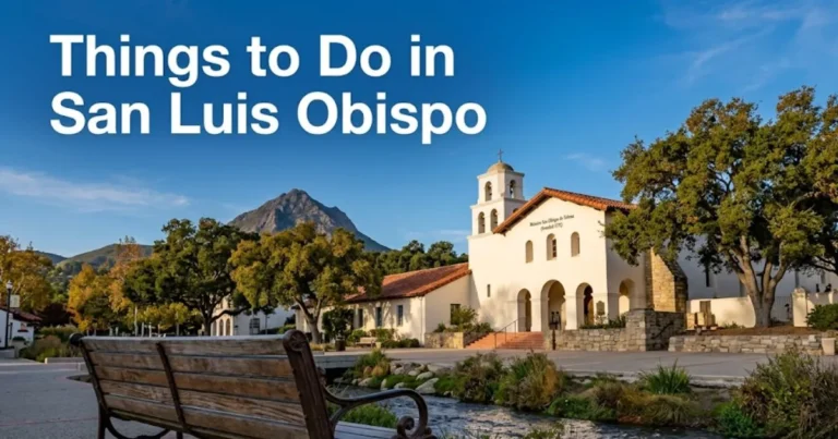
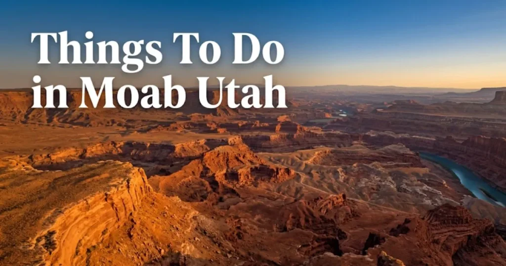
Things To Do in Moab Utah: The 2026 Complete Guide
Moab, Utah, gives you more genuinely world-class outdoor experiences per square mile than almost anywhere in the continental United States. Two national parks, Bureau of Land Management canyon country, the Colorado River, and the La Sal Mountains all sit within 40 miles of a single small-town center.
Arches National Park alone attracts over 1.8 million visitors annually, according to the National Park Service. That number means planning your Moab trip correctly in 2026 is not optional — it is the difference between extraordinary and wasted.
This guide covers every major activity, honest crowd realities, the timed-entry permit system most visitors overlook, and specific guidance for five distinct traveler profiles. Use it to build an actual itinerary, not just a wish list.
Things To Do in Moab Utah: What Makes This Place Different
The best things to do in Moab Utah go far beyond Arches National Park, though Arches deserves every bit of its reputation.
Moab sits at roughly 4,000 feet elevation in Grand County, southeastern Utah. The Colorado River cuts directly through town. Red sandstone canyon walls rise from the desert floor in formations that have no equivalent in the eastern United States.
Unlike Sedona or Zion, Moab is not a resort destination. It is a working outdoor adventure hub for serious athletes and canyon country explorers. Restaurants close early. The nightlife is minimal. The terrain is demanding and often exposed.
What Moab delivers in return is access to geological formations and canyon landscapes that took 300 million years to build. You cannot replicate that experience anywhere else in the country at this concentration.
| What Moab Does Best | What Moab Does Not Offer |
|---|---|
| Red rock hiking and canyon exploration | Urban dining and nightlife infrastructure |
| National park access (two parks) | Shade on most major trails |
| Mountain biking at world-recognized trail systems | Reliable cell service in backcountry |
| Dark sky stargazing | Flat, easy terrain for mobility-limited visitors |
| Colorado River rafting and kayaking | Large resort hotel options |
| Off-road 4WD and guided jeep experiences | Crowding-free experiences in peak season |
Couples find Moab consistently romantic in the right season. The canyon scenery at sunset is genuinely dramatic. Solo travelers do well here; the outdoor community is welcoming and guide companies are well set up for individual bookings. Families with children under age eight should research carefully, as most terrain is exposed, rocky, and demanding in heat.
Moab Utah Destination Overview and Character
Moab is a town of approximately 5,000 permanent residents surrounded by one of the most geologically dramatic landscapes in North America. Main Street runs north to south through town and is where most restaurants, gear shops, and outfitters operate.
The Colorado River Scenic Byway (US-128) begins just north of town and is itself an attraction. The town’s character is outdoor-athlete practical, not resort polished. Gear shops outnumber souvenir stores significantly.
Most visitors use Moab purely as a base camp. The actual experiences happen in the parks, on Bureau of Land Management land, and along the river. Plan to spend more time outside of town than in it.
Budget travelers note: Moab’s lodging prices surge dramatically from March through October. Camping at one of the BLM dispersed sites or established campgrounds near town is both affordable and genuinely rewarding. Sites at Goose Island Campground along the Colorado River are among the most scenically positioned in the American West.
The Grand County Travel Council is the official local tourism authority. Their site provides current event listings and area conditions. Always verify trail and road conditions before heading out, as flash flooding can close access routes without notice.
Insider Tip:
- Pack out all trash; Leave No Trace principles are actively enforced on BLM land
- Fuel up in Moab before heading to either national park; no gas is available inside either park
- The most photographed street in Moab is Center Street looking east toward the canyon walls at golden hour
Arches National Park and the Timed-Entry Permit System
Arches National Park requires a timed-entry reservation from approximately late March through early October 2026, booked in advance at recreation.gov.
This is the single most consequential planning detail for a Moab trip. Visitors who arrive without a reservation during peak season are turned away at the entrance gate. The park reaches capacity before 8:00 a.m. on many spring and fall mornings.
The reservation system typically opens 90 days in advance for the full season. Reservations sell out within hours of opening. Book your Arches reservation before booking your hotel.
To book Arches timed-entry correctly in 2026:
- Create a recreation.gov account before the reservation window opens
- Set a calendar reminder for 90 days before your target visit date
- Log in at midnight Mountain Time when reservations release
- Select a two-hour entry window; entry windows typically run from 6 a.m. through 4 p.m.
- Print or download your confirmation; cell service inside the park is unreliable
The America the Beautiful Annual Pass (approximately $80 per vehicle as of recent years) covers entry fees at both Arches and Canyonlands. It pays for itself if you visit two or more national parks on the same trip.
Delicate Arch is the park’s most famous formation and appears on Utah’s license plate. The trail is 3 miles round trip with 480 feet of elevation gain on open slickrock — no shade, no water sources on trail. Start before 7:00 a.m. in any month from May through September.
Double Arch, Balanced Rock, and the Windows Section offer extraordinary formations with significantly shorter walks. These are the best Arches options for families with children and seniors with moderate mobility.
| Arches Feature | Trail Distance | Difficulty | Best Profile |
|---|---|---|---|
| Delicate Arch | 3 mi RT | Moderate | Active adults, fit teens |
| Balanced Rock | 0.3 mi RT | Easy | Families, seniors |
| Double Arch | 0.5 mi RT | Easy | All profiles |
| Windows Loop | 1 mi RT | Easy | Families, seniors |
| Fiery Furnace | 2 mi (guided) | Strenuous | Experienced hikers |
| Landscape Arch | 1.6 mi RT | Easy-Moderate | Active adults |
Fiery Furnace requires a separate permit or a ranger-led tour. Ranger tours book out weeks in advance on recreation.gov. The Fiery Furnace experience is genuinely unlike anything else in the park.
Best Hikes in Moab Utah
The best hikes in Moab Utah range from easy canyon floor walks to strenuous slickrock scrambles, and the right choice depends entirely on your fitness level and the temperature on your visit date.
Outside Arches, Corona Arch Trail (3 miles round trip, 225 feet elevation gain) is one of the finest free hikes in the Moab area. It accesses a natural arch larger than Delicate Arch without requiring a park entry fee or reservation. Trailhead is on Potash Road, approximately 10 miles west of Moab.
Fisher Towers Trail (4.4 miles round trip) follows the base of the towering sandstone spires above the Colorado River on US-128. The trail is exposed and rocky but passable for reasonably fit hikers. The formations are unlike anything inside Arches. Parking is free at the Bureau of Land Management trailhead.
Mill Creek Canyon is a local favorite that requires no permit, charges no fee, and delivers canyon swimming in the creek during spring and early summer. The trail begins within walking distance of Main Street. It is Moab’s genuine local hiking escape.
For seniors and accessibility travelers: the paved path at Dead Horse Point State Park offers rim views comparable to the Grand Canyon’s South Rim. The main viewpoint is accessible with minimal physical demand.
Insider Tip:
- Start any exposed trail before 7:00 a.m. from May through September
- Carry at least one liter of water per hour of hiking in desert terrain
- Cryptobiotic soil crust — the dark, bumpy biological crust surrounding trails — is decades old and crushed by a single footstep; stay strictly on marked paths
Key Takeaway: Book your Arches timed-entry reservation at recreation.gov before you book your Moab hotel; the park turns visitors away at the gate without a confirmed time slot during peak season.
Moab Mountain Biking and Off-Road Adventures
Moab is one of the globally recognized centers of technical slickrock mountain biking. The Slickrock Bike Trail is the destination that established Moab’s biking reputation.
Slickrock is a 10.5-mile loop on sandstone terrain with virtually no flat sections. The practice loop (2.3 miles) is advisable even for experienced mountain bikers making their first slickrock visit. Do not underestimate the terrain if you are transitioning from trail or dirt riding. Slickrock riding style is fundamentally different.
The Moab Brand Trails system off US-191 north of town is a better starting point for intermediate riders. Bar M Loop (7.7 miles) and Deadhorse Trail (9.4 miles) within this system offer sustained technical riding without Slickrock’s extreme exposure.
Guided 4WD jeep tours access routes that standard rental vehicles cannot. Hell’s Revenge and Fins and Things are two of the most popular guided 4WD routes, both accessed from the Sand Flats Recreation Area east of Moab. Expect to pay in the range of $80 to $160 per person for half-day guided tours (verify current pricing with operators).
Solo travelers and couples find guided jeep tours a genuinely social experience. Most operators group small parties together, and the guides provide geological and historical context that self-guided driving cannot.
ATV and side-by-side rentals are widely available from multiple Moab outfitters on Main Street. These put canyon terrain within reach of visitors who are not cyclists. Rates typically run $150 to $300 per half-day depending on vehicle type (verify with operators before booking).
Budget travelers note: the Sand Flats Recreation Area charges a small day-use fee. Budget riders with their own bikes can access challenging terrain here without paying for a guided tour.
| Activity | Skill Level | Cost Range | Best Profile |
|---|---|---|---|
| Slickrock Bike Trail | Advanced | Free entry + bike rental | Experienced mountain bikers |
| Moab Brand Trails | Beginner-Intermediate | Free + bike rental | Active adults, fit teens |
| Guided Jeep Tour | Any | $80-$160 per person | Couples, solo travelers, groups |
| ATV Rental | Any | $150-$300 half-day | Couples, non-cyclists |
| White Rim Road (4WD) | Multi-day | Permit required | Adventure campers |
Colorado River Activities in Moab
The Colorado River runs directly through the Moab valley, and river activities are among the most accessible outdoor experiences for non-hikers and mixed-ability groups.
Half-day flatwater raft trips on the Colorado River above Moab are genuinely low-key. The section from Hittle Bottom (on US-128) through the Moab Daily section offers calm water appropriate for families with children as young as four or five. Multiple outfitters operate this run.
Class III to IV whitewater on the Westwater Canyon section of the Colorado suits confident swimmers and thrill-seeking adults. This run requires booking with a licensed outfitter. It is not appropriate for young children or non-swimmers.
Cataract Canyon, the most serious whitewater section on the Colorado River accessible from Moab, runs Class IV to V in spring high water. This is an expert-level or guided-only experience. Some sections become dramatically more manageable in late summer low water.
Kayak and paddleboard rentals are available for independent use on the flatwater sections. The Portal Picnic Area on US-128 is a popular launch point. Cell service on the river corridor is limited; carry a paper map of the river sections.
The Colorado River Scenic Byway (US-128) runs 44 miles along the river from Moab to I-70. Even without getting on the water, this drive delivers some of the most dramatic river canyon scenery in Utah. The road is paved and suitable for all vehicles.
Families with children: half-day flatwater rafting is one of the most universally successful Moab activities for mixed-age groups. Even young children find the canyon walls and river experience genuinely engaging.
Canyonlands National Park From Moab
Canyonlands National Park is Moab’s most undervisited major attraction, largely because it lacks the single iconic image that Arches has in Delicate Arch. That makes it a far better experience for travelers who want authentic canyon country without peak-season crowds.
The park divides into four distinct districts. Island in the Sky, the district most accessible from Moab (35 miles via US-313), sits atop a massive mesa with views across 1,500 feet of canyon to the Colorado and Green Rivers below.
Mesa Arch is the single most rewarding short walk in all of canyon country. It is a 0.5-mile loop to a perfectly framed arch on the canyon rim. Sunrise here is photographically extraordinary. Arrive before sunrise; the parking lot fills quickly on clear mornings.
Grand View Point Overlook at the end of the main park road delivers the longest canyon panorama available from a paved road in Utah. The walk from the parking area is less than half a mile. This viewpoint is accessible and appropriate for seniors and families.
The Needles District of Canyonlands, accessed via US-191 south to Utah SR-211, requires more driving (75 miles from Moab) but delivers backcountry canyon experiences without Island in the Sky’s crowds. The Chesler Park Loop (11 miles) is one of the finest day hikes in the American Southwest.
Budget travelers note: Canyonlands does not currently require timed-entry reservations. A single America the Beautiful Pass covers both Canyonlands and Arches. Canyonlands sees roughly one-third the visitation of Arches.
Key Takeaway: Mesa Arch at Canyonlands is the single most photographically rewarding short walk in southeastern Utah; arrive before sunrise and the 0.5-mile round trip takes under 30 minutes.
Dead Horse Point and Underrated Moab Alternatives
Dead Horse Point State Park is the best alternative to Arches and Canyonlands for travelers who want dramatic canyon views without national park crowds or reservation requirements.
The park sits on a 2,000-foot mesa above the Colorado River, accessible via the same road as Canyonlands Island in the Sky (Utah SR-313). The rim views are directly comparable to the Grand Canyon’s South Rim in scale. Entry runs approximately $20 per vehicle as of recent years (verify current rates before visiting).
The paved accessible path along the canyon rim makes Dead Horse Point one of the very few genuinely accessible dramatic canyon viewpoints in southeastern Utah. Seniors and travelers with mobility limitations should prioritize this park specifically.
Fisher Towers, on US-128 east of Moab, delivers towering sandstone spires rising 900 feet from the canyon floor. The Bureau of Land Management trail here is free, well-marked, and significantly less crowded than any Arches trail. Experienced climbers use Fisher Towers as a technical climbing destination. Non-climbers enjoy the base trail and the surreal rock formations.
Corona Arch is genuinely larger than Delicate Arch and is reached via a free trail on Potash Road. It appears in far fewer travel guides. That means on a busy spring weekend, you will likely have the arch to yourself. The trail involves one fixed rope section (a chain assist) near the top that most reasonably fit hikers handle without issue.
Matheson Wetlands Preserve, owned by The Nature Conservancy, sits at the edge of Moab along the Colorado River. A 2-mile trail through cottonwood and tamarisk along the river is the quietest 90-minute walk available within town limits.
Insider Tip:
- Dead Horse Point’s east overlook at sunset is less photographed than the main viewpoint but delivers equally dramatic canyon lighting
- Fisher Towers trail is best in morning light when the towers catch direct sun from the east
- Budget travelers can access Fisher Towers, Corona Arch, and Matheson Wetlands entirely free
Moab Scenic Drives and Road Trips
The most cinematic scenic drive in the Moab area is the Colorado River Scenic Byway (US-128), a 44-mile paved route running northeast from Moab along the river to Cisco and I-70.
The drive takes approximately one hour without stops. With stops at the Fisher Towers turnoff, Negro Bill Canyon trailhead, and the Castle Valley viewpoints, budget a half-day. The canyon walls change color dramatically throughout the day; midday light is flat, morning and late afternoon are optimal.
Potash Road (Utah SR-279) runs southwest from Moab along the Colorado River to a dead end at potash evaporation ponds. The road passes ancient Ute rock art panels visible from the road’s edge, the Corona Arch trailhead, and towering canyon walls. This 17-mile dead-end drive is one of the most underused spectacular routes in the region.
La Sal Mountain Loop Road climbs from canyon desert at 4,000 feet to alpine forest at over 8,500 feet within 30 miles. The contrast is striking: red rock desert gives way to aspen groves and mountain meadows. Fall color on this route, typically peaking in late September and early October, rivals anything in Colorado.
Day trips from Moab extend to Newspaper Rock State Historic Monument, 53 miles south via US-191 and SR-211, where one of the largest collections of Fremont and Ancestral Puebloan petroglyphs in the region concentrates on a single canyon wall. Entry is free.
Couples find the scenic drives the most naturally romantic Moab experience, particularly at golden hour. No permits, no crowds at these specific viewpoints, no physical demands.
| Drive | Distance from Moab | Highlights | Best Time |
|---|---|---|---|
| Colorado River Scenic Byway (US-128) | Starts in town | Fisher Towers, Castle Valley | Morning or late afternoon |
| Potash Road (SR-279) | Starts in town | Rock art, Corona Arch trail | Morning |
| La Sal Mountain Loop | 15 mi east via SR-128 | Alpine contrast, fall color | Sept-Oct for foliage |
| Newspaper Rock/SR-211 | 53 mi south | Petroglyphs, Needles approach | Any season |
| Dead Horse Point Road (SR-313) | 30 mi north | Canyonlands and Dead Horse access | Morning or sunset |
Key Takeaway: Potash Road (SR-279) is Moab’s most underused scenic drive, offers free rock art viewing, and delivers canyon scenery equal to the national parks without any entry fee or reservation.
Moab Canyoneering and Rock Climbing
Moab and the surrounding Bureau of Land Management canyon country is one of the premier canyoneering and rock climbing regions in North America. The sandstone formations that make the landscape visually distinctive are also technically climbable in ways that granite and limestone are not.
Canyoneering involves navigating canyon slots using a combination of hiking, scrambling, and rappelling. The Escalante Canyon area south of Moab, and numerous slot canyons on BLM land near Moab, offer guided canyoneering for beginners through advanced groups. No technical experience is required for beginner-level guided trips.
Rock climbing in the Moab area centers on routes at Wall Street (on Potash Road), Indian Creek (within Canyonlands Needles area), and Long Canyon. Indian Creek is internationally recognized as one of the finest crack climbing areas in the world. It is technical and expert-only; non-climbers should not attempt it without guided instruction.
Several Moab outfitters offer half-day introduction-to-canyoneering experiences appropriate for fit adults with no prior technical experience. Prices typically run in the $100 to $175 per person range for guided half-day trips (verify with operators before booking).
Solo travelers seeking to meet other adventure-oriented travelers often find guided canyoneering trips the most socially rewarding Moab experience. Small group sizes and shared physical challenge build genuine connections.
Safety note: Never attempt slot canyons without checking weather forecasts for the entire upstream watershed. Flash floods can rush through a slot canyon from a storm miles away with no warning at the canyon floor. This is not a minor caution; it is life-safety information.
Moab Stargazing and Night Sky Experiences
Moab is one of the premier dark sky destinations in the American West, surrounded by some of the least light-polluted terrain on the continent. The International Dark-Sky Association has recognized the Moab area and surrounding canyon country for exceptional night sky quality.
On a clear moonless night, the Milky Way is visible to the naked eye from virtually anywhere outside of Moab’s town center. The canyon walls create a natural amphitheater that frames the night sky in a way that flat prairie dark sky sites cannot replicate.
The best stargazing access near Moab is from the canyon rim at Dead Horse Point State Park, where the park operates ranger-led astronomy programs seasonally (verify current program schedules with Utah State Parks before visiting). The combination of 2,000-foot canyon below and full-sky view above is extraordinary.
Canyonlands Island in the Sky is a designated Dark Sky Park under the National Park Service’s Night Skies program. The park road is open until 10:00 p.m. seasonally, allowing access to Grand View Point under a dark sky. The Milky Way framing over the canyon is among the finest natural viewpoints in the country for astrophotography.
Couples consistently rate Moab stargazing as one of the destination’s most unexpectedly powerful experiences. No equipment is necessary. A simple blanket and a moonless forecast are the only requirements.
Best months for Moab stargazing: November through February deliver the darkest skies and longest nights. Spring and fall offer the best combination of mild temperatures and darkness. Summer delivers darkness but extreme overnight heat.
Insider Tip:
- Check the moon phase calendar before your trip dates; a full moon dramatically reduces sky darkness
- The BLM dispersed camping areas along the Colorado River have zero light pollution
- Bring a red-light headlamp; white lights destroy night-adapted vision
Moab Utah Restaurants and Local Dining
Moab’s dining scene is small-town practical rather than culinary-destination-grade. But several restaurants consistently overdeliver for a town of 5,000 people in the middle of canyon country.
Desert Bistro on Williams Way is the most consistently cited fine-dining option in Moab. It operates in a historic house setting and sources regionally. Reservations are strongly advisable for dinner during spring and fall peak season.
Moab Brewery on Main Street is the local gathering point for post-trail recovery. The space is large, consistently crowded after 5:00 p.m., and serves the full range of their on-site brewed beers alongside approachable food. No reservations; expect a wait in peak season.
EklectiCafe on North Main Street serves breakfast and lunch and is the most locally patronized morning option. The eggs Benedict and breakfast burritos are consistently recommended on local community forums. Arrive before 8:00 a.m. to beat the trail-prep crowd.
For a quick, inexpensive, genuinely good lunch before a park visit, Zax Restaurant on Redcliff Lane has served Moab residents for decades. It is not photogenic. It is reliable and fast.
Budget travelers note: Grocery options in Moab include a City Market on Williams Way and a Natural Grocers on South Main Street. Packing a trail lunch is both cheaper and more practical than seeking food inside either national park, where no dining services exist.
Families with children find Moab’s dining scene manageable; most restaurants are casual and child-tolerant. The challenge is that popular dinner spots fill quickly after 5:30 p.m. from March through October. Eat early or wait.
Key Takeaway: Book Desert Bistro reservations before you arrive in Moab during spring or fall peak season; it fills daily and walk-ins are rarely accommodated on busy weekend evenings.
Free and Budget-Friendly Things To Do in Moab Utah
Moab’s best experiences include a significant number of free and genuinely low-cost options. National park entry fees are the largest budget item; the America the Beautiful Annual Pass eliminates that cost for visitors hitting multiple parks.
Free and low-cost Moab activities:
- Corona Arch Trail (Potash Road): 3 miles round trip, free, no permit required
- Fisher Towers Trail (US-128): 4.4 miles round trip, free BLM access
- Mill Creek Canyon: walkable from Moab town center, free, canyon swimming in spring
- Matheson Wetlands Preserve: 2-mile river trail, free, managed by The Nature Conservancy
- Potash Road rock art panels: visible from roadside, free, no hiking required
- Newspaper Rock State Historic Monument: free entry, one of the densest petroglyph panels in the Southwest
- Colorado River Scenic Byway (US-128): free drive, pullouts at major viewpoints along entire route
- Moab Giants Dinosaur Park: nominal entry fee; genuinely engaging for children and paleontology-interested adults
The America the Beautiful Annual Pass costs approximately $80 per vehicle as of recent years and covers entry to both Arches and Canyonlands. If you plan to visit both parks, this pass pays for itself.
Camping on BLM dispersed land surrounding Moab is free with a 14-day stay limit per site. Some established BLM campgrounds have small nightly fees. This is by far the most cost-effective accommodation option for budget-conscious travelers.
Budget travelers who avoid guided tours, cook their own food, and camp on BLM land can experience the full range of Moab’s most compelling natural landscapes for under $30 per day in total park and access costs.
| Experience | Cost | Permit Required |
|---|---|---|
| Corona Arch Trail | Free | No |
| Fisher Towers Trail | Free | No |
| Arches National Park | ~$35/vehicle (verify) | Yes: timed-entry reservation |
| Canyonlands National Park | ~$35/vehicle (verify) | No timed-entry currently |
| Dead Horse Point State Park | ~$20/vehicle (verify) | No |
| Mill Creek Canyon | Free | No |
| Newspaper Rock | Free | No |
| BLM Dispersed Camping | Free | 14-day limit |
| America the Beautiful Pass | ~$80/vehicle/year | Covers multiple parks |
Best Time To Visit Moab Utah
The best time to visit Moab Utah is mid-March through May or mid-September through October. These windows offer mild temperatures, manageable crowds, and peak scenic conditions.
Spring (mid-March to May): Temperatures range from the high 50s to low 80s Fahrenheit. Desert wildflowers bloom in March and April. Crowds build significantly through April and peak around Easter weekend, which coincides with the annual Easter Jeep Safari. Book accommodations three or more months ahead if your spring trip overlaps with Easter week.
Fall (September to October): September temperatures cool from summer highs into the 70s and 80s. La Sal Mountain aspen foliage typically peaks in late September. This is the most scenically complete season in the Moab area. Crowds are significant but slightly below spring peaks.
Summer (June to August): Daytime temperatures regularly exceed 100°F and can reach 110°F. Most exposed trails become genuinely dangerous between 10:00 a.m. and 4:00 p.m. This is peak visitation season despite being the worst conditions for the region’s primary outdoor activities. If visiting in summer, plan all outdoor activity before 8:00 a.m. or after 6:00 p.m.
Winter (December to February): Moab sees dramatically fewer visitors. Some trails may have ice at higher elevations. Temperatures in town range from the 20s overnight to the 50s in the afternoon. The canyon light in winter is exceptional for photography. This is the best season for travelers who prioritize solitude.
| Season | Temp Range | Crowds | Best Activities |
|---|---|---|---|
| Spring (Mar-May) | 55-85°F | High | Hiking, biking, rafting start |
| Summer (Jun-Aug) | 85-110°F | Peak | Early morning only; avoid midday |
| Fall (Sep-Oct) | 60-85°F | High-Moderate | All activities, La Sal foliage |
| Winter (Nov-Feb) | 25-55°F | Low | Scenic drives, photography, solitude |
Moab Itinerary: One-Day and Weekend Frameworks
One Day in Moab Utah:
- Wake before dawn and drive to Mesa Arch in Canyonlands Island in the Sky (35 miles). Arrive for sunrise. The Milky Way and canyon walls frame the arch for the first 20 minutes of light.
- Drive back toward Moab and stop at Dead Horse Point State Park for the canyon rim walk (1.5 hours total).
- Return to Moab for breakfast at EklectiCafe on North Main Street (arrive by 8:30 a.m.).
- Drive Potash Road (SR-279) to the rock art panels and Corona Arch trailhead (complete the hike in 2 to 2.5 hours). Return to Moab by noon.
- Lunch at Moab Brewery or grab provisions at City Market for a riverside picnic on US-128.
- Drive the Colorado River Scenic Byway (US-128) northeast to Fisher Towers in the afternoon (the towers catch best light from 3:00 to 6:00 p.m.).
- Return to Moab for dinner at Desert Bistro (reservation required).
- Drive 2 miles from town for post-dinner stargazing on BLM land along the Colorado River.
Weekend in Moab Utah (2 Days):
Day 1: Execute the one-day itinerary above.
Day 2:
- Enter Arches National Park at your reserved timed-entry window (book at recreation.gov 90 days in advance).
- Walk Balanced Rock and the Windows Section first (both under 1 mile; complete before 9:00 a.m.).
- Hike Delicate Arch next (3 miles round trip). Start no later than 7:00 a.m. in any month from April through September.
- Have a picnic at one of Arches’ designated pullouts rather than backtracking to Moab for lunch.
- Spend the afternoon at Mill Creek Canyon within walking distance of Main Street. Swim in the canyon pools if spring runoff levels allow.
- Optional evening: ranger-led program at Dead Horse Point (check current schedule with Utah State Parks).
Families with young children: Replace Delicate Arch with the Landscape Arch trail (1.6 miles round trip, relatively flat) inside Arches. The Windows Section and Double Arch are the family-optimal choices for high-reward, low-demand hikes.
Seniors: The one-day itinerary works well with modifications. Replace Corona Arch (chain assist section) with the Potash Road drive and viewpoints only. Dead Horse Point’s accessible rim path is the day’s hiking highlight.
Practical Logistics and Safety for Moab Utah
Getting to Moab requires a car. There is no public transit connecting Moab to either national park. The nearest major airport is Salt Lake City International (SLC), approximately 4 hours north via I-15 and US-191.
Grand Junction Regional Airport (GJT) in Colorado is 1.5 hours east of Moab and offers a shorter drive with connections through Denver. Canyonlands Field Airport (CNY) is 18 miles north of Moab with limited seasonal service; verify current routes before planning around it.
Getting around Moab: A rental vehicle is essential. Main Street attractions are walkable but neither national park nor most trailheads are within walking distance. Reserve your rental vehicle at Salt Lake City or Grand Junction well in advance for spring and fall travel; Moab’s limited local supply sells out.
Parking inside Arches is critically limited even with a timed-entry permit. By 9:00 a.m. in peak season, the Delicate Arch trailhead lot and the Windows Section lot are both full. Arrive at opening or plan to wait for a parking space.
Safety and Practical Warnings for Moab Utah
Moab’s desert terrain is genuinely hazardous for unprepared visitors. Heat is the primary risk from May through September.
Key safety and practical facts every visitor should know:
- Carry a minimum of 1 liter of water per person per hour of outdoor activity. Most emergency rescues in Moab involve dehydration and heat exhaustion, not trail accidents.
- Do not enter slot canyons or narrow canyon sections without checking weather forecasts for the entire upstream watershed. Flash floods travel faster than a person can run and give no warning at ground level.
- Cell service is absent or unreliable on most trails, in most of Arches, and across Canyonlands. Download offline maps via AllTrails or the National Park Service app before leaving your vehicle.
- Altitude adjustment: Moab is at 4,000 feet. Some surrounding terrain reaches 8,500 feet. Travelers arriving from sea level should hydrate aggressively for the first 24 hours.
- Cryptobiotic soil crust is the dark, lumpy biological crust surrounding all marked trails. A single footstep destroys decades of biological growth. Stay on rock or marked trail surfaces at all times.
- Wildlife awareness: rattlesnakes are present in the desert terrain. Watch where you place hands and feet on rocky scrambles.
- Moab Regional Hospital is located on Williams Way in town. For backcountry emergencies, the National Park Service maintains ranger stations in both Arches and Canyonlands with emergency communication capabilities.
- Sun protection is non-negotiable. Most Moab trails are entirely exposed. Sunscreen, sun-protective clothing, and a hat are not optional on any outdoor activity.
Always tell someone your planned route and expected return time before entering backcountry terrain. This is the single most effective safety measure for any Moab backcountry visit.
Frequently Asked Questions About Things To Do in Moab Utah
Do you need a reservation to visit Arches National Park in 2026?
Yes, Arches National Park requires a timed-entry reservation from approximately late March through early October 2026.
Reservations are booked at recreation.gov and typically open 90 days in advance for each date.
Without a confirmed reservation, visitors are turned away at the entrance gate during peak season. Book before your Moab hotel and before your flights if possible.
What is the best time of year to visit Moab Utah?
The best time to visit Moab Utah is mid-March through May or September through October.
These shoulder seasons offer temperatures in the 60s to 80s Fahrenheit, manageable crowds, and the full range of outdoor activities without summer heat restrictions.
June through August temperatures regularly exceed 100°F, which makes most exposed Moab trails genuinely dangerous between 10:00 a.m. and 4:00 p.m.
How many days do you need in Moab Utah?
Three to four days is the practical minimum for covering Arches, Canyonlands, Dead Horse Point, and the major scenic drives.
Two days works if you move efficiently and accept that you will miss either the Needles District of Canyonlands or the Colorado River Scenic Byway.
A full week allows the Needles District, La Sal Mountain Loop, Newspaper Rock, Fisher Towers, and meaningful time on the water.
What can you do in Moab if you don’t hike?
Non-hikers can enjoy guided jeep tours, ATV and side-by-side rentals, flatwater rafting on the Colorado River, scenic drives on US-128 and Potash Road, and stargazing on BLM land.
The Dead Horse Point State Park accessible rim path and the rock art panels visible from Potash Road require minimal walking.
Moab’s canyon scenery is genuinely dramatic from a vehicle window; a well-planned scenic drive covers extraordinary terrain without demanding physical fitness.
Is Moab Utah good for families with kids?
Moab is good for families with older children (ages eight and up) who are comfortable with some physical activity and heat.
Young children and toddlers face genuine challenges: most trails are exposed, rocky, and shaded by nothing; summer heat is dangerous for small children; and trail terrain is not stroller-compatible.
For families visiting with young children, the best options are the Windows Section inside Arches, flatwater rafting on the Colorado River, and the Moab Giants Dinosaur Park.
How far is Moab Utah from Salt Lake City?
Moab Utah is approximately 235 miles from Salt Lake City, a drive of roughly 3.5 to 4 hours via I-15 south to US-6 east and then US-191 south.
The drive is straightforward on interstate and two-lane highway with no particularly difficult mountain passes.
Grand Junction, Colorado, is approximately 110 miles east via US-191 north to I-70, making it a shorter drive option for travelers flying into GJT.
Plan Your Moab Trip Starting Today
Moab rewards travelers who plan specifically and rewards them with the most geologically dramatic landscape in the continental United States. The single most important booking step is securing your Arches timed-entry reservation at recreation.gov, ideally 90 days before your visit date. Everything else follows from that.
Book your Arches reservation first. Then your accommodations or campsite. Then verify current timed-entry requirements, entry fees, and seasonal conditions directly with the National Park Service and the Grand County Travel Council before departure.
Travel conditions, prices, permit requirements, and seasonal availability in Moab change regularly. Confirm all key logistics with official sources in the weeks before your trip. The visitor who arrives prepared uses every hour of their Moab stay. The one who arrives without a reservation may spend their first morning in the Arches entrance line heading the wrong direction.